Parcel Patterns, Culture, and Power
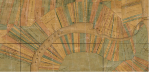
Detail of a map of the parishes of Pointe Coupee, West Baton Rouge and Iberville including parts of the parishes of St. Martins and Ascension, Louisiana, 1859
I highly recommend Torn in Two: the 150th Anniversary of the Civil War at the Boston Public Library (open through December of this year). The exhibition is primarily comprised of maps from the Norman B. Leventhal Map Center and includes great examples of information design – mostly to communicate a complicated social and political story (before the Civil War) and the geography of the southern United States and the developing war (during the Civil War) – to new public audiences in northern cities.
The best part of the exhibition is a comparison of the plantations that front the Mississippi River near Baton Rouge, Louisiana (a map from 1859 above) with a map of central Lowell, MA at the birth of the industrial revolution in 1850. The juxtaposition between the land use patterns where cotton was grown and where the raw material was manufactured into textiles sums up the radical differences in culture between the two regions of the country. The logic of long skinny plantation parcels parallel to the river – maximizing the number of parcels with water access – is the same as the early plot plan of Providence, Rhode Island.
You can zoom into the Baton Rouge plantation map to see more detail and see other maps at the Norman B. Leventhal Map Center website.
-Tim
